Food Deserts
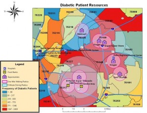
The Dallas-Fort Worth Hospital Council Foundation is coming out with the final Dallas County Diabetes Environmental Resources document on Dec. 16, 2011. Results were extremely interesting, with one aspect of the study determining if areas with high prevalence of diabetes were located in “food deserts.” Food deserts are areas with low income residents lacking locations to purchase fresh foods outside of a walking one-mile radius or driving five-mile radius. Area codes 75149, 75150, 75217 and 75227 were considered food deserts.
In the map below, grocery stores are labeled with small purple houses, with pink circles around the houses to show the walking and driving radius. Hospitals are noted by blue rectangles with an “H.” Food banks are designated by yellow circles with silverware. Most of the resources are located in clusters rather than spread out over zip code areas. These are areas with healthy choices of fresh fruits and vegetables for local residents. Many fast food restaurants and convenient stores were also located in these areas. Diabetes patients in the zip codes noted above have very few choices with the exception of fast food restaurants and conveniences stores.
For more information please contact: Pam D. Doughty, Ph.D.

